Amics del Museu de Xàbia
  • Home
    • Qui Som?
    • ¿Quienes Somos?
    • About Us
    • Calendario
    • Actas
    • Assemblea anual 2022
  • Blogs
    • Activitats
    • Actividades
    • Activities
    • Museu de Xàbia Blog
  • Projectes
    • Premio de Investigación - Formularios de Inscripción
    • Traducciones Translations >
      • DISPLAY PANELS - GROUND FLOOR >
        • THE STONE AGES - PALAEOLITHIC, EPIPALAEOLITHIC AND NEOLITHIC
        • CAVE PAINTINGS (ARTE RUPESTRE)
        • CHALCOLITHIC (Copper) & BRONZE AGES
        • THE IBERIAN CULTURE (THE IRON AGE)
        • THE IBERIAN TREASURE OF XÀBIA
        • THE ROMAN SETTLEMENTS OF XÀBIA
        • THE ROMAN SITE AT PUNTA DE L'ARENAL
        • THE MUNTANYAR NECROPOLIS
        • ARCHITECTURAL DECORATIONS OF THE PUNTA DE L'ARENAL
        • THE ATZÚBIA SITE
        • THE MINYANA SMITHY
      • Translations archive
      • Quaderns: Versión castellana >
        • 1. La Romanización en las tierras de Xàbia
        • 2. Xàbia en la Modernidad
        • 3. La prehistoria de Xàbia y su entorno
      • Quaderns: English versions >
        • 1. Romanisation of Xàbia
        • 2. Xàbia in the Modern Era
        • 3. The Prehistory of Xàbia and its surroundings.
    • Catálogo de castillos regionales >
      • Castells / Castillos / Castles - Intro
      • Castillo de Aielo de Rugat
      • Castillo de Alcalá (Benisili)
      • Castillo de Borró
      • Castillo de Carbonera
      • Castillo de Castalla
      • Castillo de Chio /Xiu (Llutxent)
      • Castillo de Enguera
      • Castillo de Montesa
      • Inventario
    • Exposició - Castells Andalusins >
      • Intro - Valenciá
    • Exposición - Castillos Andalusíes >
      • Intro - Castellano
    • Exhibition - Islamic castles >
      • Intro and menu - English
    • Sylvia A. Schofield - Libros donados
    • Mejorar la entrada/improve the entrance >
      • Proyecto - fotos
      • Cartel Roll-up
  • Historia y enlaces
    • Historía de Xàbia >
      • Els papers de l'arxiu, Xàbia / los papeles del archivo
      • La Cova del Barranc del Migdia
      • El Vell Cementeri de Xàbia
      • El Torpedinament del Vapor Germanine
      • El Saladar i les Salines
      • La Telegrafía y la Casa de Cable
      • Pescadores de Xàbia
      • La Caseta de Biot
      • Castell de la Granadella
      • La Guerra Civil / the Spanish civil war >
        • Intro - La Guerra Civil / the Spanish civil war
        • El refugi de la guerra del moll de Xàbia
        • l'Arquitectura de la Guerra a Xàbia
        • Planos - Refugi Moll
    • History of Xàbia (English articles) >
      • The Castle of Granadella
      • Ermita del Pòpul - a brief history
      • Telegraphy and the Casa del Cable
      • Civil war architecture in Xàbia
      • Cemetery of San Joan
      • Cova del Migdía
      • Quintus Sertorius - the "Braveheart" of Hispania
    • Charlas y excursiones / talks and excursions >
      • Fotos de actividades
      • Expo Iran - MARQ
      • La Illyeta dels Banyets
      • Al Azraq
      • La Pilota Valenciana
      • Pla de Petracos
      • Cova del Comte - Pedreguer
    • Investigacions del museu - Museum investigations
    • Enllaços
    • Enlaces
    • Links
  • Social media
    • Facebook
    • Twitter
    • You Tube
  • Visitas virtuales
    • Museu de Xàbia
    • Iglesia de San Bartolomé
    • Capella Santa Anna
    • Ermita de Santa Llúcia
    • Ermita de San Joan
    • Santuario de la Mare de Déu dels Àngels
    • Ermita del Popul
    • Ermita del Calvario
    • Casa tradicional l'Escaldá
    • Casa tradicional Carrer Nou
  • Tenda Tienda Shop
    • Souvenirs
    • Llibres / libros / books

9. Castles of the Laguar valley and Orba

Back to intro and menu
Picture
Click on the image to enlarge it
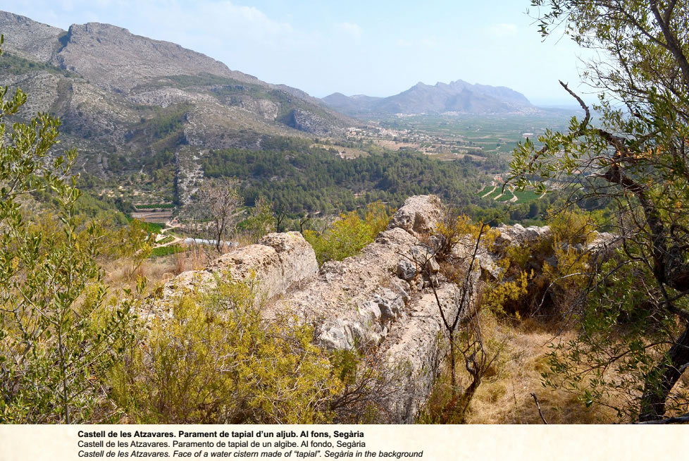
The castle of Atzavares or la Plana, occupies a hill 350 meters high, which controls the entrance to the Laguar valley (Vall de Laguar) from the coastal plain, as well as the headwaters of the Laguar or Girona River which feed into the Barranco del Infierno. 

Although the building was demolished in 1283 by order of King Pere (the Great), two enclosures are still visible. The outer enclosure, corresponding to the albacar, is delimited by a tapial wall which is now razed to ground level. In the north this is replaced by a cliff which creates a natural defence. The slope is not as steep to the west. This was where the entrance would have been, and where you can see a half demolished water cistern.
​
The upper enclosure is on the top, and some inside walls remain, but they are so badly torn down that it is not possible to make out any structures apart from another water tank
The castle was the place of refuge for the farmsteads of Campell, Fleix and Benimaurell located in the Vall de Laguar, and Portella, Tormos, Orba and Isber from lands lower down. Its date of construction is unknown, but ceramics found on site suggest the 11th century. The castle was occupied by Al-Azraq during the revolt of 1276, and was demolished once it had been captured by the Christian King. However, this did not stop the Morisco rebels occupying the place in 1609 during their efforts to evade expulsion.

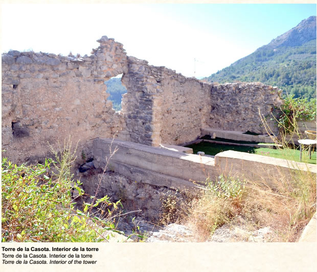
​The Casota tower is located on a promontory 400m high not far from the town of Fleix, about 30 meters to the east. It stands near the old road that went up the valley from Campell and Fleix to Benimaurell.

The building had become part of a farm house that masked it until the modern structures were demolished and the tower was revealed for everyone to see. 

Archaeological work documented a rectangular tower, 10.30m x 7m, with a wall thickness of almost a metre.

The maximum preserved height of 3m is found on the north and east sides, while the other sides have been demolished almost to ground level. The foundation of the building is masonry built on the bedrock to level the land prior to construction with tapial form-work. The east wall has an entrance which was probably opened when the tower was dismantled.

Picture
Click on the image to enlarge it
The original structure would have had a ground floor and two floors with a flat roof. Its function would be to provide shelter from the farmsteads near Fleix and Campell. There is no documentation about the tower, but according to archaeological evidence it was built between the second third of the 12th century and the middle of the 13th century. It fulfilled its function over a short period since it was destroyed between the second half of the 13th century and the first third of the 14th century. Its present state of ruin cannot be explained except that it would have been demolished after the revolt of Al-Azraq or after 1276.
PictureClick on the image to enlarge it


​


​

​


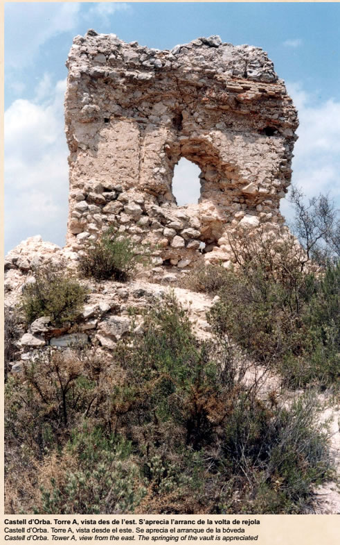
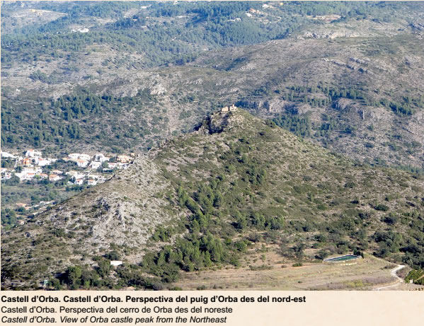
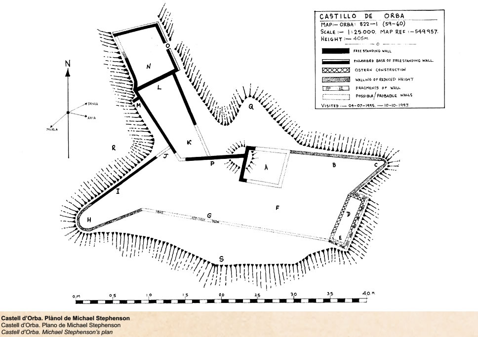
Orba castle stands on a hill at an altitude of 416 m to the north-west of the Sierra Seguili, known in documents as puig d'Orba (Mount Orba), which controlled both Orba itself and Murla.

The remains we now see correspond to a building which was authorised by the Christian King to Berenguer Mercer in 1289. The building was the residence of whomsoever was the lord of Murla, representing the feudal power in the area.

The structures are very damaged, but from west to east can be seen a large tower, a large rectangular room, a small square tower, a stretch of wall and a water cistern. In addition, there is another cistern at the bottom of the southern side in the place where the access road to the fortification begins. The slope overlooking Orba is steeper and difficult to ascend. Much of the castle is of the Christian era and no previous constructions have been found, although there are many Islamic ceramics on the ground which could indicate the existence of a previous Islamic fortification. 

(Note: This castle is sometimes called the Castillo de Awraba, since the name Awraba or Awrba was once thought to have been the original Islamic name for Orba. However, ancient texts describe the location of “Awrba” as being on the route between Xàtiva/Denia and Valencia/Denia. The texts also describe the location of an iron mine – all of which suggests that Awrba was actually Oliva)
Picture
Click on the image to enlarge it
Picture
Click on the image to enlarge it
Click here to download a PDF of the panel
Powered by Create your own unique website with customizable templates.
  • Home
    • Qui Som?
    • ¿Quienes Somos?
    • About Us
    • Calendario
    • Actas
    • Assemblea anual 2022
  • Blogs
    • Activitats
    • Actividades
    • Activities
    • Museu de Xàbia Blog
  • Projectes
    • Premio de Investigación - Formularios de Inscripción
    • Traducciones Translations >
      • DISPLAY PANELS - GROUND FLOOR >
        • THE STONE AGES - PALAEOLITHIC, EPIPALAEOLITHIC AND NEOLITHIC
        • CAVE PAINTINGS (ARTE RUPESTRE)
        • CHALCOLITHIC (Copper) & BRONZE AGES
        • THE IBERIAN CULTURE (THE IRON AGE)
        • THE IBERIAN TREASURE OF XÀBIA
        • THE ROMAN SETTLEMENTS OF XÀBIA
        • THE ROMAN SITE AT PUNTA DE L'ARENAL
        • THE MUNTANYAR NECROPOLIS
        • ARCHITECTURAL DECORATIONS OF THE PUNTA DE L'ARENAL
        • THE ATZÚBIA SITE
        • THE MINYANA SMITHY
      • Translations archive
      • Quaderns: Versión castellana >
        • 1. La Romanización en las tierras de Xàbia
        • 2. Xàbia en la Modernidad
        • 3. La prehistoria de Xàbia y su entorno
      • Quaderns: English versions >
        • 1. Romanisation of Xàbia
        • 2. Xàbia in the Modern Era
        • 3. The Prehistory of Xàbia and its surroundings.
    • Catálogo de castillos regionales >
      • Castells / Castillos / Castles - Intro
      • Castillo de Aielo de Rugat
      • Castillo de Alcalá (Benisili)
      • Castillo de Borró
      • Castillo de Carbonera
      • Castillo de Castalla
      • Castillo de Chio /Xiu (Llutxent)
      • Castillo de Enguera
      • Castillo de Montesa
      • Inventario
    • Exposició - Castells Andalusins >
      • Intro - Valenciá
    • Exposición - Castillos Andalusíes >
      • Intro - Castellano
    • Exhibition - Islamic castles >
      • Intro and menu - English
    • Sylvia A. Schofield - Libros donados
    • Mejorar la entrada/improve the entrance >
      • Proyecto - fotos
      • Cartel Roll-up
  • Historia y enlaces
    • Historía de Xàbia >
      • Els papers de l'arxiu, Xàbia / los papeles del archivo
      • La Cova del Barranc del Migdia
      • El Vell Cementeri de Xàbia
      • El Torpedinament del Vapor Germanine
      • El Saladar i les Salines
      • La Telegrafía y la Casa de Cable
      • Pescadores de Xàbia
      • La Caseta de Biot
      • Castell de la Granadella
      • La Guerra Civil / the Spanish civil war >
        • Intro - La Guerra Civil / the Spanish civil war
        • El refugi de la guerra del moll de Xàbia
        • l'Arquitectura de la Guerra a Xàbia
        • Planos - Refugi Moll
    • History of Xàbia (English articles) >
      • The Castle of Granadella
      • Ermita del Pòpul - a brief history
      • Telegraphy and the Casa del Cable
      • Civil war architecture in Xàbia
      • Cemetery of San Joan
      • Cova del Migdía
      • Quintus Sertorius - the "Braveheart" of Hispania
    • Charlas y excursiones / talks and excursions >
      • Fotos de actividades
      • Expo Iran - MARQ
      • La Illyeta dels Banyets
      • Al Azraq
      • La Pilota Valenciana
      • Pla de Petracos
      • Cova del Comte - Pedreguer
    • Investigacions del museu - Museum investigations
    • Enllaços
    • Enlaces
    • Links
  • Social media
    • Facebook
    • Twitter
    • You Tube
  • Visitas virtuales
    • Museu de Xàbia
    • Iglesia de San Bartolomé
    • Capella Santa Anna
    • Ermita de Santa Llúcia
    • Ermita de San Joan
    • Santuario de la Mare de Déu dels Àngels
    • Ermita del Popul
    • Ermita del Calvario
    • Casa tradicional l'Escaldá
    • Casa tradicional Carrer Nou
  • Tenda Tienda Shop
    • Souvenirs
    • Llibres / libros / books